Getting energy from the annual ESRI Nederland GIS conference in Rotterdam. Highlights for me: 1) Nice demo by Dutch-speaking American guy (who was that guy?) from Swiss firm Procedural of an ArcGIS 3D application, including shadows cast by new construction in Rotterdam, with analysis of how much sunlight would be lost ( video ). There was a droll suggestion that letters could be sent to people who would be living in the shadows… right! 2) Fascinating demo by Dirk Aalbers, at HORUS, Surround Vision, of little cars driving around making movies and capturing information using image recognition. Infrared videos could also classify buildings according to heat loss. 3) Presentation by Jack Verouden, Chief Surveyor at Shell. Shell is looking at alternative energy sources, including worldwide studies of biomass potential. Go for it, Shell! 4) Excellent presentation by Jan Willem VanEck, director of strategy at ESRI in the Netherlands, about GIS and Social Media. He showed a wonderful application developed together with his son, which allows you to map your LinkedIn connections (no longer available). Now I am truly inspired!
Update 3/9/2018: : Mapmyconnections seems to be gone, but Jan Willem van Eck is still going strong.
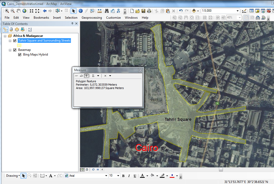 Estimates of people at the Cairo protest vary from 10,000 to 2 million. Using ArcGIS to outline an polygon which might represent the heaviest crowd, the area is 104,000 square meters. Assuming a rather tight crowd, the average could be 2 people per square meter. So my estimate is 200,000 people give or take 50,000. And of course there are masses, coming and going, and in all the streets not included in the polygon. Anyway, impressive, but not a million. I don’t think it matters.