Oil spill maps

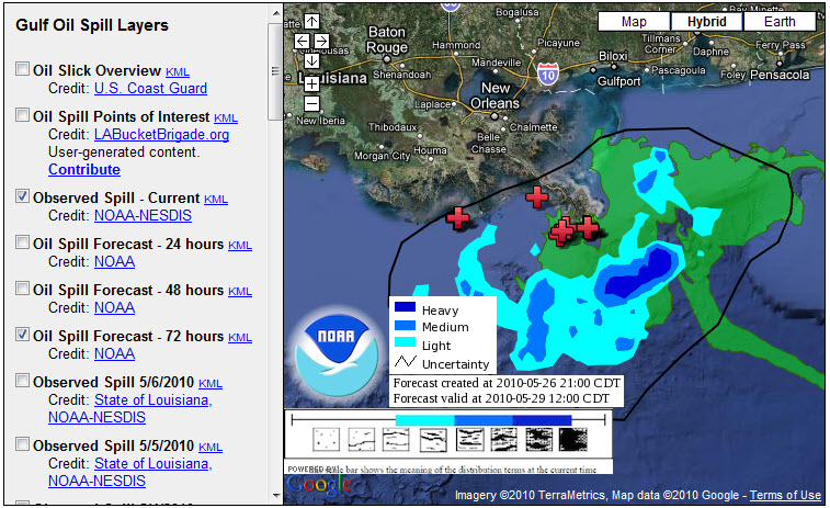
Three ways to view the spill’s progress:   1)  Google Crisis center, with map data from NOAA  and PBS live news feed showing the gushing oil, and 2) Paul Rademakers Google Earth representation of the (no longer works), showing how it compares in size to Manhattan, London, Paris, etc, 3) New York Times”Tracking the Oil Spill in the Gulf“,map updated daily.

Update 3/9/2018: The Times site is still available. Wikipedia’s report is a good way to look back at the crisis and aftermath.

Geocoded Art

At this beautiful new site, Geocoded Art, landscape paintings are geocoded and can be searched with a map interface.  Or you can look up a favorite work by artist or title, and find out where in the world it was painted.  All works are in the public domain.  This is already a rich database which hopefully will continue to grow.  This will surely be a favorite for art-history courses, giving context to paintings.  However the stated goal is also “to use fine art to illuminate geography”.  Found this via Google Maps Mania.

Update 6/7/2018: Geocoded Art seems a bit neglected, but works.  Google Maps Mania still going strong!  Amazing mashups, so many to investigate.  Wandered over to David Rumsey collection site.  Must return soon.  

Amsterdam op z’n kop

Amsterdam standing on its head?  New features for Google Maps (click on a little green vial in top right corner), provide some interesting options, including a rotate button so we can view of the world as the Aussie’s see it.  Zoomed in locally, Amsterdam looks more like the city depicted by 16th century cartographers starting with Cornelis Anthonisz.

The new features also include a handy zoom box tool (draw a box around your destination),  and a tool tip for plotting the latitude and longitude.   Google announced last Friday that Google Maps will be getting more new gadgets, with its own “Maps Lab.”

Update 6/7/2018:  Nowadays (Graduating from the Lab), Google Maps in satellite view, CTRL+ mouse drag for full 360 views.