Wonders of Reddit – Colonial America


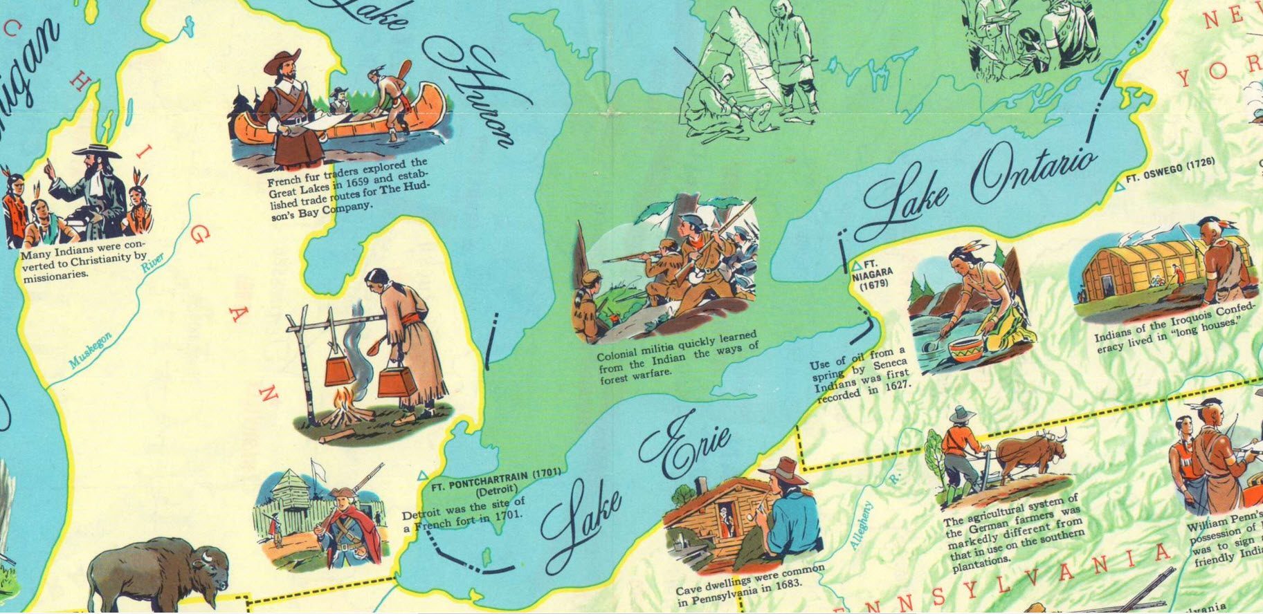
Very, very late to this game, I’m discovering the wonders of Reddit – specifically the subreddit “Map Porn“, and the title sums it up. For starter, there is this 1957 educational map created by Esso Standard Oil which was recently posted. The comments are also great, including critique that the Dutch flag and colors are wrong… and that this was an America without slavery!

Note also, that Seneca Indians in New York State used oil from a spring (second zoomed image) – apparently for medicinal purposes. Fun fact (as they say), this is recorded as the discovery of oil in America! Dive in here – also an interactive map website. No more oil here, but a rich history.

The David Rumsey Collection

I’ve known about the exciting David Rumsey Historical Map Collection for more than a decade, and have used it from time to time as a resource for research. The physical collection has more than 150,000 maps, mostly of North and South America, but also the rest of the world. About two thirds of the collection have been digitized and with this database are easily searchable.
The technology used includes LUNA software (by Luna Imaging in L.A.) for creation and processing, and Georeferencer software from the Swiss company Klokan Technologies. With this software, the transparency of the historical map can be adjusted to see the google-maps layer below. Fascinating!

Who Owns the North Pole

Just watched a wonderful BBC documentary series, “Mapping the World“, which focuses on the use of maps throughout history for national power.  The last segment focuses on the current amazing new competition to claim the rapidly melting arctic region because of its enormous oil and gas reserves.  This has been in the news for some time, especially since the Russians planted a titanium flag on the sea floor directly below the North Pole in August 2007.  This map was designed by cartographers at Durham University, updated in 2010 to include negotiated boundaries between Norway and Russia, in attempt to make agreements before the free-for-all which could result from competing national interests as the area is explored.

Cultural Heritage on a Map

The firm AB-C Media, based in Utrecht, works with Museums, Archives, and Cities to make their collections available to the public through interactive databases and map applications. A showcase of the possibilities can be seen with the richly detailed and interactive Amersfoort Map – Amersfoort op de Kaart In addition to Art Work, national and local monuments and archeology, the map has a number of prepared Walking Routes, like the one pictured left. From the detailed information windows, users can also leave comments, or look at the featured item in Google streetview. For Amerersfoort and other projects, the collection can also be viewed on a mobile application, erfgoed.mobi. All in all, a beautifully conceived site!

Dutch Canons – Cultural History on the Map

ABC Media is a web design company which designs websites for cultural heritage, including archeology, history, art, literature and music. Their customers include museums, archives, monuments and cultural institutions. They use an open source database system, Umbraco, which makes it possible for clients to easily maintain the databases themselves. The Regiocannons website is an amazing map interface which provides access to all the dutch regional canons of cultural history.  Zooming in shows more and more monuments, with links to all the detail.  Great to study for my “inburgeringscursus“!

Crowdsourcing History

The New York Public Library’s Lionel Pincus Map Library has an amazing tool, The NYPL Map Warper, which allows and encourages the public to help geo-rectify their collection of historical maps. Over 2200 maps have been rectified to date.

The tool is a customized version of an open source map warping/rectifying tool (MapWarper) created by Tim Waters and MIT licensed, so available to developers. On the Mapwarper site, you can upload your own scanned maps and use the tool to rectify and export! The base map is Open Source, but after exporting, a map could be layered onto Google Maps or anything else.

Crowd Counting

Estimates of people at the Cairo protest vary from 10,000 to 2 million. Using ArcGIS to outline an polygon which might represent the heaviest crowd, the area is 104,000 square meters. Assuming a rather tight crowd, the average could be 2 people per square meter. So my estimate is 200,000 people give or take 50,000. And of course there are masses, coming and going, and in all the streets not included in the polygon. Anyway, impressive, but not a million. I don’t think it matters.

Amsterdam Growth Map

The Amsterdam Historical Museum has upgraded its Amsterdam “growth map” with a googlemaps-based version created by the Dutch multimedia firm Mapsplusmotion. These developers have done similar maps for Rotterdam and Manhattan.

A variation on these maps is a website with photos from the 1960s. It would be interesting to see a mashup with photos or drawings of buildings from the period, tied to the map.

Update 3/9/2018:  The Mapsplusmotion website  inactive.  The new website is: Mappinghistory.nl.  New maps for WestFries and the Hague are now available.

Sailing Up

The Henry Hudson 400 website has a dazzling new map mash-up.  Using a “layering system” thirty-two historical maps and Henry’s four routes can be displayed on top of Google Maps, with variable transparency.  Places and events related to this year’s celebration can be “turned in” revealing a wealth of historical information.  There is even an opportunity for the public to add information to the map.  The clever and rich map application was created by Cartosoft , a Portland-based neo-geo company with some great applications for new age mapmakers.   The Hudson 400-year celebration is picking up steam (has wind in its sails).  In September a fleet of traditional Dutch flat bottom boats (botters) will sail up the Hudson from New York to Albany.  I’m going to try to hitch a ride.

Update 5/7/2018: Such a a pity.  None of the original links work properly any more.  Henry Hudson 400 site is there, but the map no longer functions, and Cartosoft has disappeared.  It was fun while it lasted.

Maps in Lund


Lund, Sweden was founded sometime between 990 and 1020, and is filled with treasures for visitors today.  According to the Wikipedia, it is applying to be a “European Capital of Culture” in 2014, when a Swedish city again has a turn to hold this honor.  Lund University has over 40,000 students (though many live in other places).  We have just learned that the University offers an online Masters in GIS, free of charge. (How can this be??) We will investigate further.

Other interesting sights near Lund included the new western harbor area in Malmo, Vastra Hamnen, and another new “model development”, Jakriborg.  My collage is from Google Earth, including the 3D rendering of Santiago Calitrava’s twisting torso. One surprise after the next.

Update 17/6/2018: The Lund University masters program has a few scholarships for a free online international GIS Masters program, but the normal price is currently 10,000 euros.