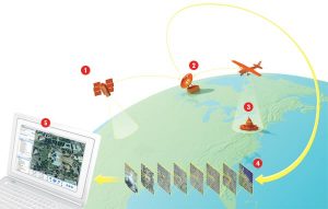
How Google Maps
 There’s a nice article in Technology Review, How Google Maps the World, with a simple explanation of the process from satellite to website. Makes it sound so easy. By the way, the company producing most of the high resolution satellite images is DigitalGlobe, and if you want to buy just one of the little snapshots, say a shot of the Dam Square as an 8 x 10 print, it will cost you $19.95, so I guess we can be happy Google is footing the bill for the earth. (Thank you Richard.)
Update 16/6/2018 – new website for DigitalGlobe, more features, ask for quote.
DigitalGlobe is a cool Satelite company providing imagery for just about everyone. Their next satelite series to be launched in 2020/21 is described in Wikipedia:
“WorldView-Legion: Currently being built by SSL, WorldView-Legion is DigitalGlobe’s next generation of earth observation satellites. WorldView-Legion consists of six satellites planned to launch in the 2020/2021 time frame into a mix of sun-synchronous and mid-latitude orbits.[31] These satellites will replace imaging capability currently provided by DigitalGlobe’s WorldView-1, WorldView-2 and GeoEye-1 Earth observation satellites. WorldView-Legion is contracted to launch on a two flight proven SpaceX Falcon 9 missions.”

Leave a Reply
Want to join the discussion?Feel free to contribute!