Interesting links
Here are some interesting links for you! Enjoy your stay :)Categories
- Animals
- Augmented Reality
- Bing Maps
- Books
- Cartography
- Climate
- Conferences
- Crowdsourcing
- Data Sources
- Economy
- Education
- Environment
- ESRI
- Flash Maps
- Geography
- Geology
- GIS and Health
- Google Earth and Sky
- Google Maps and Mashups
- Health
- History
- Humor
- Map Art
- Mobile
- Pollitics
- Social Networking
- Technical
- Television
- Tools
- Trends
- Urban Planning
- Water
- Weather
- Website Design
- Wordpress
Archive
- October 2020
- September 2020
- May 2020
- March 2020
- July 2019
- November 2013
- September 2013
- April 2013
- March 2013
- February 2013
- January 2013
- December 2012
- November 2012
- September 2012
- July 2012
- June 2012
- May 2012
- April 2012
- February 2012
- December 2011
- November 2011
- September 2011
- August 2011
- May 2011
- March 2011
- February 2011
- January 2011
- December 2010
- September 2010
- July 2010
- February 2010
- October 2009
- July 2009
- June 2009
- May 2009
- April 2009
- March 2009
- December 2008
- November 2008
- October 2008
- September 2008
- July 2008
- June 2008
- May 2008
- April 2008
- March 2008
- February 2008
- January 2008
- December 2007
- November 2007
- October 2007
- September 2007
- August 2007
Adaptation
/0 Comments/in Climate /by Nina KFUpdate June 2018 – Article co-authored by Aerts titled Integrating Human Behavior Dynamics into Flood Disaster Risk Asessment (available for a price!)
This news article describes the contents. https://www.cmcc.it/article/human-behavior-is-the-key-to-reducing-flood-risk
Map of Maps
/0 Comments/in History /by Nina KFAn example is this charming Leo Belgicus which reminds us that maps were fun even back then.
Sniggering with Maps For US
/in Humor /by Nina KFUpdate: 27/6/2018: 67 million people have viewed the video. Miss South Carolina, Caitlin, had a rough time after the video went viral, but seems ok for now. The website MapsForUs.org, meanwhile, has not fared so well. Doesn’t exist.
NYC Subway Map (Under the Radar)
/0 Comments/in Google Maps and Mashups /by Nina KF28-05-2018 update: The link above no longer works. Google themselves incorporated public transportation onto their maps in June 2012, releasing transit directions for 475 regions around the world. (Not sure when exactly NYC subways were included.)
See the blog for developments in the Google Maps Platform since 2008.
Mapki for GM api knowledge
/0 Comments/in Technical /by Nina KFDiscovered two resources which will help a lot: 1) Mapki – A wiki (knowledge base) on Google maps API, and 2) Google Maps Tutorial by Mike Williams. Gonna read that one cover-to-cover. Best I’ve seen so far.
Google Sky
/0 Comments/in Google Earth and Sky /by Nina KFUpdate May 31, 2018 – Just downloaded current desktop version of Google Earth. In the top bar there is a “planet” button, and there’s where you find Google Sky, along with Mars and the Moon. Ten years further, there is no doubt masses of new information, about the celestial masses. The online version (chrome) of Google Earth does not currently support the “planet” views.
Back to Earth – Africa
/0 Comments/in Google Earth and Sky /by Nina KFThese two images give an idea of the visual impact. 1) Africa is enormous, looks like half the earth here, with CAR outlined like a heart in its center, and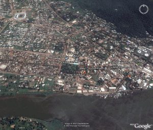 2) zoom in to the town of Bangui and it is just a village, with coffee shops, a Chinese restaurant, a football stadium, university, and government buildings, along a great winding river. So much to be learned here!
Live Hurricane and Weather Tools from GEB
/0 Comments/in Google Earth and Sky /by Nina KFUpdate 31-5-2018: Many of the links here seem no longer useful. No doubt there are many new sites and apps for hurricane tracking. Google has their own highly-rated Android app, Seastorm.
MS Researach with GIS
/0 Comments/in GIS and Health /by Nina KFUpdate 31/5/2018: Where is she now? Starting a promising career it seems. Megan Blewett.
New York Times on GIS Jobs Growth
/0 Comments/in History /by Nina KFLink to the article: Technology Reveals New Worlds to Map
A New York Times article by Barbara Whitaker today highlights the growth of private sector GIS (geographic information systems) jobs.
“Many jobs are with the government, but technological advances have also helped drive private-sector jobs. The Bureau of Labor Statistics lists G.I.S.-related jobs as among the fastest-growing new or emerging fields. More companies see the value of G.I.S. services, and there are not enough people to fill all the available jobs, said Richard Serby, a founder of GeoSearch, which recruits people for jobs in mapping sciences.”